It’s Time to Plan that Easter Trip to Copper Canyon, Mexico!

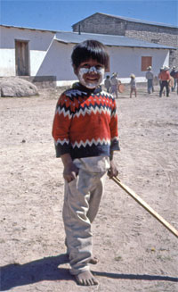
A young Tarahumara boy is all dressed up for Easter in Mexico's Copper Canyon
A young Tarahumara boy is all dressed up for the Easter ceremonies in Mexico's Copper Canyon

Easter is fast approaching and one of the most colorful and interesting places to celebrate is in Mexico’s Copper Canyon. The sleepy small towns are full of tourists—both Mexican and foreign—who have come to see the Easter celebrations of the Tarahumara Indians. The Tarahumara are outwardly Catholic, but their version of Catholicism is unlike any form we are familiar with.

Of all the religious ceremonies throughout the year, The Easter celebrations are the most important. Hundreds of men, women, and children converge on the local church from villages as far away as fifteen miles. These celebrations are for socializing and having a good time, but the Indians also expect their efforts to please God so that He will give them long lives, abundant crops, and healthy children.

To read the whole story behind these celebrations and traditions, Click here.

The celebrations begin on the Saturday prior to Palm Sunday, with speeches and ritualized dances. The Pharisees, their bodies smeared with white earth, and the Soldados dance to the beating of drums and the melody of reed whistles. About midnight, a mass is held in the church. Shortly after sunrise, bowls of beef stew, stacks of tortillas and tamales and bundles of ground, parched maize, are lifted to the cardinal directions, allowing the aroma to waft heavenward to be consumed by God. The food is then distributed among the people. At mid-morning the Soldados and Pharisees set up wooden crosses marking the stations of the cross, a mass is held, and the priest leads a procession around the churchyard, with the participants carrying palm branches.
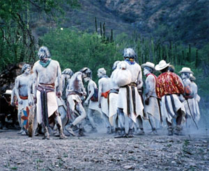
Tarahumara men celebrate Easter in Mexico's Copper Canyon
Tarahumara men dance around a fire as part of the Easter celebrations in Mexico's Copper Canyon

Three days later, on Holy Wednesday, the ceremonies resume, and for the next three days there are processions around the church, to protect the church and, by extension, God and God’s wife.

On the afternoon of Good Friday, the Pharisees appear with three figures made of wood and long grasses representing Judas, Judas’s wife, and their dog. Judas and his wife wear Mexican-style clothing and display their oversized genitalia prominently. The Pharisees and Soldados parade the figures around the church, dancing before them. The Pharisees then hide the figures away for the night.

On Saturday morning, the Soldados and Pharisees engage in wrestling matches, battling symbolically for control of Judas. The Soldados then take possession, shoot arrows into the three figures and set them afire. The people retire to continue the celebrations at the many tesguino drinking parties.
On the Road to Mandalay Where the Flyin’ Fishes Play–or Not

“On the Road to Mandalay, Where the flyin’ fishes play, An’ the dawn comes up like thunder outer China ’crost the bay.” – Rudyard Kipling
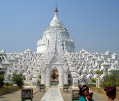
LLocated in Mingun (near Mandalay), the Hsinbyume Pagoda is built in circular terraces representing mountain ranges.
Located in Mingun (near Mandalay), the Hsinbyume Pagoda is built in circular terraces representing mountain ranges.

In 1892 Rudyard Kipling published Barrack Room Ballads, a collection of poems about the life of British soldiers stationed in colonial India. It included the poem “Mandalay,” in which a lovelorn soldier longs to return to Burma and his Burmese sweetheart. While the road to Mandalay may not necessarily lead to love, it does lead travelers to a fascinating experience of Myanmar’s culture and history.

The fabled city of Mandalay lies on the banks of the Ayeyarwady River. The last capital of Myanmar before the British took over in 1886, it is second only to Yangon (Rangoon) in size and lies in the center of the country. It was founded by King Mindon in 1857 in an empty area that, according to prophecy, would be the location of a town that would come into existence on the 2,400th jubilee of Buddhism. To fulfill this prophecy, the king moved his capital from Amarapura, dismantling the wooden buildings and royal palaces and loading them onto carts and elephants to relocate them seven miles south to Mandalay.

The city gets its name from Mandalay Hill, which rises more than 700 feet above the Mandalay Fort. Visitors can climb up two covered stairways that wind up the hill, stopping at the shrines, stupas and monasteries along the way. Near the top is a standing Buddha image pointing to the place where the city would be built according to the prophecy. Once on top, visitors are rewarded with sweeping views of the plains, the Palace and the Shan mountains in the distance.

The road to Mandalay is a route studded with ancient cities, where cars share the road with ox carts and markets teem with life. Although most of the significant buildings in the ancient royal capital of Amarapura were moved to Mandalay, some interesting structures still remain. The most picturesque is U Bein’s Bridge, the longest teak bridge in the world, which stretches three-quarters of a mile across Taungthaman Lake. A stroll across the busy bridge is a great way to experience the local ambiance. At one end of the bridge is the Maha Ganayon Kyaung monastery, where thousands of young monks live and study in a strictly disciplined setting. Each day at 11 a.m. they may be observed eating their main meal in complete silence.

A few miles south down the road is the ancient city of Ava (Inwa), which was the capital of the northern kingdom for almost 400 years, succeeding the nearby city of Sagaing. Both of these cities boast a number of interesting pagodas and historic sites.

One of the most interesting of the ancient cities on the road to Mandalay is Mingun, where in 1790 King Bodawpaya decided he would build the world’s largest pagoda. Despite employing thousands of slaves and prisoners to build it, he died before it was completed. What remains is the massive brick base that stands over 50 meters high. Although damaged by an earthquake, it is possible to climb the ruins for a wonderful view. The king also had a gigantic bell cast—weighing 90 tons, it hangs nearby and is the largest ringing bell in the world.

There is much to see on the road to Mandalay, but unlike the poem, there are no flying fishes and, alas, China is not across the bay.

Please join us on one of our California Native Myanmar Adventures.

Flying on a Dragon

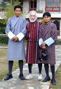
California Native founder Lee Klein with our driver and guide in traditional Bhutanese attire.
California Native founder, Lee Klein (center), along with our Bhutanese driver and guide, wears the traditional Bhutanese 'gho'.

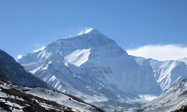
Soaring through the sky, on possibly the world’s most spectacular flight, the snow-covered peaks of the Himalayas come into view. On our left is Everest, the “top of the world,” accompanied by a vast panorama of the Earth’s highest mountains. We are headed for Paro, the only international airport in the Kingdom of Bhutan, aboard Druk Air, the Royal Bhutanese Airline. The word Druk means “Dragon,” and our flying dragon is the only airline allowed to enter the country.

As we approach Paro, our plane drops steeply down and enters a deep valley, weaving its way between the mountains in a breathtaking and slightly scary descent to a smooth landing at the little airport, originally built by the British military. And then we are there, walking across the concrete to the small terminal building and our first visit to the “Shangri-La” country of Bhutan.

Druk Air was established by Royal Proclamation in 1981 and began operations in 1983 when its first plane, an 18-seat German Dornier 228-220, landed at Paro carrying the Royal Flag of the Kingdom. The airline, whose fleet now consists of four aircraft, two British Aerospace 70 passenger BAe146-100’s and two new 124 passenger Airbus A319’s, is the smallest national carrier in the world.

All takeoffs and landings at Paro are by Visual Flight Rules (VFR). This means that the pilot must be able to see the runway and all of the surrounding hills. He cannot land or take off using instruments. No flights operate at night or in poor visibility. Flights can sometimes be delayed up to a day or two due to inclement weather. The airline operates from Paro to six cities: Bangkok and Calcutta, four times a week, Katmandu and New Delhi, twice a week, and Dhaka and Yangon, once a week. Flights from Bangkok make a stop to take on extra fuel in case they cannot land at Paro and have to return. Druk Air’s safety record is perfect—they have been flying for twenty-three years and never had an accident!

After going through immigration, (they have a photo on file of everyone scheduled to enter their country), and meeting our tour guide, we look back and see the airport staff closing the airport—after all, on most days there is only one flight in and one flight out of the country.

We invite you to join us on a California Native tour to Bhutan, this amazing little country at the roof of the world.

Keep Those Cards and Letters Coming

Mailman

Back when I was a college student in the 70’s, traveling the world, I was rarely in touch with my family and friends. To talk on the phone, we had to schedule a time and I had to call collect. Even then it was very expensive and everyone talked fast so as not to rack up too big of a phone bill. Then there were those kiosks that charged a premium to be able to call overseas. It was a hassle.

So, most of the communication at that time with the family was by letter. That’s right, pen, light paper or aerogram*, and an “airmail” envelope and stamps. Written words! Friends got post cards. I always shopped long and hard to find post cards that most exemplified the destination. Some had multiple pictures, and some just some really beautiful view that I had actually seen. I also purchased postcards for myself at each destination so that, in case photos didn’t come out well, I’d still have pictures. The post cards went into the album with the photos.

Communication has changed dramatically for the traveler. How many actually write letters? Send Post cards? These days your every move can be documented for all to see in real time, at little to no cost. Between Facebook, online photo albums and blogs, all that’s needed is some free WiFi and a computer or Smart Phone, and you can communicate with the world. You never have to pick up a pen. And photos? If it didn’t come out well, just take another and another until you have the shot you want.

But what of the lost art of letters and postcards? Recently I went through some boxes of “memories” and found several letters and post cards I’d sent home during that college year. I spent hours reading them and reliving the fun times. It was wonderful. Now if I want to look back on a recent trip, there is not much to see except the digital photos, but with time I will forget where I was and all the little nuances that are not in the short caption.

Email letters can be printed and kept, but consider a post card or two as you travel—maybe even sent to your own address. What a wonderful way to remember your trip in years to come.

*The US Postal Service stopped printing aerograms in 2006.

Lost in the Galapagos

“The day was overpoweringly hot, and the lake looked clear and blue: I hurried down the cindery slope, and, choked with dust, eagerly tasted the water—but, to my sorrow, I found it salt as brine.” — The Voyage of the Beagle, Charles Darwin

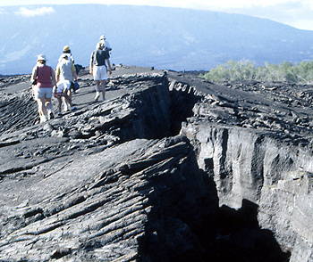
California Natives explore Isabela Island in the Galapagos.
California Natives hike over the volcanic terrain on the Galapago's Isabela Island (formerly called Albermarle Island).

The soldier looked again at the terrible landscape—thorny, dry vegetation, fields of sharp broken lava, and the volcanoes, following each other as far as his dry eyes could see.

Isabela Island, named after Queen Isabela of Spain, called Albermarle Island by the British, is the largest of the many islands and islets which make up the Galapagos. Larger, at almost 1,800 square miles, than all of the other islands put together. Six volcanoes form the backbone of the island, all but one of which are active, and the island, particularly the northern part, is wild and rugged.

In 1893, Don Antonio Gil settled on the island on a plantation he called Villamil. There he dabbled in agriculture and mining, rendered turtle oil, and exploited feral cattle for their hides. He also exploited the abundant tortoises, using their shells to decorate the path up to the plantation.

Thirty miles inland on the slopes of a mountain, he established a second plantation, Santo Tomas, primarily for mining sulfur from the fumaroles in the area.

Other plantations sprung up on the island as time went on because of it´s abundant resources. It was the custom in those days for plantations such as these to employ workers who were fugitives of the law. This made discipline on the plantations very harsh. Punishments could include death or exile, and some plantation owners traded workers for cattle.

As the plantations grew in size and number of workers, the owners petitioned the government of Ecuador for police and military protection, although there had been no trouble thus far on the island. In 1902 two small garrisons were dispatched to the island, consisting of a total of 12 soldiers. Nothing much happened, and the soldiers became terribly bored. So bored, in fact, that they decided to secretly leave the island.

In 1904, eleven of the soldiers quietly set out towards the interior of the island carrying neither water or supplies, certain they would be able to find a way back to the mainland. The owners of the plantations, realizing they were gone, searched for days but never found them.

After awhile, they gave up hope and had all but forgotten about the missing soldiers, when one of them, near death, reappeared at the plantation entrance. Once nursed back to health, he explained that the soldiers left thinking that such a big island should be filled with villages, and that they would be able to find sea transport back to Guyaquil. Overtaken by hunger and thirst, they began to hallucinate, and eventually separated. None, except the one survivor, was ever seen or heard from again.

There are so many strange stories, landscapes, and creatures on these islands which inspired Charles Darwin to discover the principles of evolution. Please join us our Galapagos Islands tours.

Traveling Easy With The California Native

Traveling EasyIts summer vacation time! As many of us travel this summer, we see longer lines, airline cut backs and fees, not to mention unpredictable weather. Here are a few simple tips to make your trip a wonderful adventure to remember.
Attitude is key! If you start with a good attitude, others you encounter will mirror that, and you can handle anything that happens.

Be flexible. Sometimes things happen, good or bad, changing your plans in an instant. If you are willing to just smile and “go with the flow,” you will certainly have an adventure, and it may even be better than the original plan.

Pack LightPack light. This can’t be emphasized enough. If you plan carefully, you’ll have everything you need and you can carry it on the plane, avoiding luggage fees. Pack layers instead of bulky items for cold weather. Pick a color scheme and pack mix- and-match items you can wear in many combinations. Have a master packing list on your computer. Before each trip, print it out, modifying it for the length of the trip and the weather.

Pack chargers for your iPod, cell phone, camera battery, computers, etc. Also pack an extension cord. This way, if the outlets in a hotel room are limited, you can plug three things on one cord, and if you need a voltage converter or adapter, you need carry only one. Pack loose batteries in a plastic bag in your carry-on. Since January 1, 2008, lithium batteries are permitted in checked luggage only if installed in the electronic device.

Pack everything in a carry-on suitcase and a backpack, in neat layers. Stow your carry-on in the overhead bin and your backpack under the seat (ladies, put your handbag in the backpack!). Make sure any liquids or gels are 3 oz. or under, and stored in one quart-sized zip-lock bag that is easy for airport security to inspect. Also, take some twist ties. These are great for securing zippers on luggage when you are on the move and can be taken off easily at security.

If you must check luggage, make sure you have your toiletries, medications, electronics and chargers, and a change of clothes in your carry-on. Lost luggage can put a real damper on a trip. Pack an extra bag that packs flat, for those once-in-a-lifetime purchases and souvenirs. Check this bag on the way home. Many airport luggage shops sell them. Check your airline’s website for any specific luggage restrictions.

Time Your ArrivalTime your airport arrival to give yourself enough time to get through security, but don’t arrive so early that you spend hours sitting around. Check to see which carriers fly from the same terminal. A lot of short-haul airlines usually mean a longer security line. Check your airline’s website for flight status updates which send text or voice messages to your cell phone advising you of your gate number, and changes, delays, etc. Since most U.S. domestic flights no longer provide meals, we like to get to the airport for a morning flight in time to get through security, then sit down and have a nice breakfast.

Speaking of food, if you are flying domestically in coach, bring your favorite snacks. Although airlines sell a variety of items, you’ll save money and have healthier snacks you enjoy. For flights during mealtimes, buy a sandwich and drink after going through security. If you buy them in advance, be careful about liquids—salad dressing, drinks, sauces, etc. may be confiscated.

Our packing essentials for any trip: bathing suit, hand sanitizer pads, or gel (in your quart-sized plastic bag), bandana (has many uses), extension cord, head lamp (great for reading), plastic bags, twist ties, small tripod for camera, small rolls of toilet paper, and most important, a good attitude and a smile.

Summer is also a good time to book your trips for the Fall. Check out all of our exciting vacation destinations.

Running at the Bottom of Copper Canyon

Since 2003,  runners have traveled to the depths of Mexico’s Copper Canyon to participate in a 50-mile foot race. This has now become an annual March event, known as the Copper Canyon Ultra Marathon (an ultra is longer than the usual 26.2 miles of a regular marathon).

The races are organized by “Caballo Blanco,” a gringo who has for years lived among the Tarahumara, or Raramuri (the running people), of Copper Canyon. The race begins in the canyon-bottom town of Urique. The participants are  taken on hikes along the trails that will be the race course days later. On race day, almost the whole town gathers to cheer on the racers—both the gringos (a group that gets larger every year) and the local Tarahumara, wearing their very “technical” footware—thin sandals made from old tires. The course features three loops of 18, 22 and 10 miles of difficult terrain that begin and end in the town. In this year’s race, which was held on March 6, only two gringos finished in the top 10.

While the Raramuri run from their homes and caves in the mountains to Urique, many make their way to the race by way of Paraiso del Oso near Cerocahui, also a stop on California Native’s popular trips to Copper Canyon.

Mexico’s Flag Day

Mexican Flag

On February 24, Mexico celebrates Dia de la Bandera, or Flag Day, a civic holiday with parades and festivities to honor the Mexican Flag. On that date in 1821, the Plan de Iguala, which proclaimed Mexico as an independent country, was signed.

The green, white and red flag was adopted at that time and although it has undergone some revisions since, the basic design has remained. Its stripes are green for hope and victory (or Independence), white is for the purity of ideals (or Roman Catholicism), and red for the blood of national heroes (or for the Union).

In the center of the flag is the National Coat of Arms which features an eagle with a snake in it’s claws. According to legend, the Aztecs, who were the original inhabitants of Mexico, were told by their gods to find an eagle perched on a prickly pear cactus and holding a snake. At this location they would build their permanent city. The story goes that they saw this eagle on an island in the middle of a lake, and built their city, now known as México City, around the island.

Throughout all of Mexico, you will see that the most respected symbol among the Mexican people, is their national flag. ¡Viva México!

Happy Valentine’s Day in Mexico

No date for Valentine’s Day this year? No problem if you are in Mexico.Happy Valentine's Day from The California Native.

Although St. Valentine’s Day probably started as a pre-Christian observance, it later became a minor religious holiday honoring St. Valentine. It was celebrated in Europe privately as a day near the end of winter and the beginning of Spring to express romance. It started to become a more public holiday in the U.S. in the mid 1800’s when a Massachusetts stationer started mass producing Valentine’s Day cards and selling them in her shop. It has grown and grown and is now celebrated in most countries of the world as a day of love and romance (seemingly not at all private!).

In Mexico, the day is called día del amor y la amistad, which means day of love AND friendship. It has evolved as a day to show appreciation for people you care about—and that doesn’t mean it has to be your significant other—it can be anyone you care about, from your teacher, your co-worker or best friend. Flowers, poems, gifts and food are exchanged as much with friends as with lovers. So, think about taking your significant other to enjoy the friendship of Mexico on Valentine’s Day or any time of year. Or join us on one of our tours to Mexico’s Copper Canyon or Yucatan.

Happy Valentine’s day to all our California Native friends!

Back to the Classics for the Naxi Orchestra

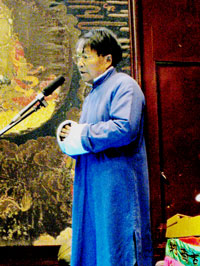
The “Ancient Musicians” of the Naxi (pronounced “Na-shee”) Orchestra are tuning up as Xuan Ke takes his place at the podium. He is younger than many of the musicians, being only in his seventy-seventh year. The standing-room only crowd gives him a thunderous applause. He addresses them in three languages: English, Mandarin, and Naxi—the ethnic dialect of the area. He has been ill, he tells them, so tonight he will conduct only the first part of the concert, then an apprentice will take over. He introduces the musicians, describes their instruments, and acquaints the audience with the history of the ancient music. Then the concert begins.

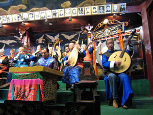
 'Ancient Musicians' of China's Naxi Orchestra
In Lijiang, China, the “Ancient Musicians” of the Naxi Orchestra again play the traditional music, banned during the Cultural Revolution.

The concert hall is unheated and cold, but the music is warm, beautiful and haunting. We are seated in one of the front rows of the hall, a beautiful building in the old town of Lijiang, located in a picturesque valley in China’s Yunnan province. Though it is January, there are plenty of tourists, most of whom are Chinese.

The Naxi Orchestra is made up of 20-24 members, many in their 80’s and 90’s, dressed in bright traditional costumes. Tonight, because of the cold, we catch glimpses of jeans and warm Western clothing beneath their silk brocaded Chinese gowns. They are playing traditional Chinese stringed instruments like the guzheng, guqin and erhu, accompanied by the dizi—the Chinese bamboo flute. Although they play some traditional Han music (Han are China’s largest ethnic group accounting for 90% of the country’s population), they specialize in dongjing, a type of Taoist temple music that has been lost elsewhere in China. The melodies evoke waterfalls, birdsong, and other sounds from nature.

Xuan Ke, the venerable Conductor, popular in China and worldwide, has a shock of dark hair and dark skin. Born in 1930, the musicologist and former village school teacher first learned about music from American Pentecostal missionaries. At the urging of his merchant father, he studied Western music at the Kunming Academy. He became passionate about exploring the instrumental music, chants and folk songs of the remote mountain villages in the foothills of the Himalayas.

Naxi Orchestra conductor Xuan Ke addresses the audience in the city of Lijiang, China.

After Chairman Mao Tse-tung’s victory in 1949, Xuan Ke became a conductor in Kunming. When the Red Army entered the city, his orchestra played Schubert’s Marche Militaire. In 1958, when Mao decided that artists and intellectuals could be a threat to him, Xuan Ke, who played western music and was fluent in English, was sent for “re-education” to a forced labor camp. He spent the next twenty years working in a tin mine. There he endured constant work and was tortured. Once the guards strung him to the roof beams by his hands, his arms extended in the manner of an orchestra conductor—or the curcified Christ. He still bears the scars and disfigurement on his hands and wrists. Many of the musicians in the orchestra suffered as well, but a good number were able to save their precious antique instruments from the Red Army by embedding them in walls or burying them in the ground.

After his release, Xuan Ke taught English and at the same time put his orchestra back together. Many of his friends had died, but some remained and the orchestra today is made up of white-bearded veterans and the young apprentices to whom they are imparting their unique knowledge of the ancient music. The orchestra has performed in more than twenty countries. At home, it plays every evening and the room is always packed.

After an earthquake struck Lijiang in 1996, the old town survived almost intact but the new town suffered a large amount of damage. It was then decided that all future building should be done in the same manner as the old town. In 1997, Lijiang, the only ancient Chinese city constructed without walls, was designated a UNESCO World Heritage Site.

The California Native invites you to visit this fascinating area of China and attend a performance of the Naxi Orchestra.