A Picturesque Paradise on the Road to Copper Canyon

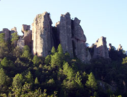
The valley of Paraiso del Oso, located just outside of Cerocahui.
The valley of Paraiso del Oso, located just outside of Cerocahui, is named for its rock formations, one of which looks like Yogi Bear.

Nestled in a picturesque valley surrounded by Mexico’s magnificent Sierra Madre Mountains, is the little village of Cerocahui, the most beautiful of all the mountain villages of southwestern Chihuahua State.

Cerocahui, with its old mission church, was founded in 1680 by the Italian Jesuit, Juan Maria de Salvatierra. It is said that Father Salvatierra, who founded many missions in the area, considered this to be his favorite.

Over the centuries, the 300-year old church, with its lovely stained glass windows, fell into disrepair. In 1948 it was extensively reconstructed. Services are now held there for the towns people and the local Tarahumara Indians, and the church also operates an Indian orphanage and boarding school.

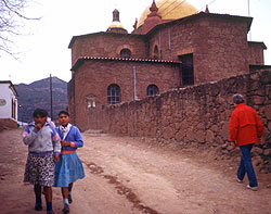
The little village of Cerocahui in Mexico's Sierra Madre mountains.
School girls and a visitor stroll by the old church in the Sierra Madre village of Cerocahui.

Walking around Cerocahui, which has a population of around 1500, you can find people with skills which seem to belong to a bygone era. There are cowboys, prospectors, blacksmiths, and a man who makes rawhide lariats.

Just a mile from “downtown” Cerocahui is the Paraiso del Oso Lodge, located in a picturesque valley, surrounded by large rock formations. The lodge is owned and operated by American Doug Rhodes, who takes pride in the delicious Mexican food served at his lodge and in the fine horses he offers to guests who wish to ride.

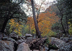
Autumn in Cerocahui.
Autumn is a beautiful time to visit Cerocahui on your trip through Mexico's Copper Canyon.

From the lodge, Doug offers a one-day tour down to the bottom of the canyon and the old silver mining town of Urique. Established in 1612, Urique was active eight years before the first pilgrims landed on Plymouth Rock.

Join us on one of our trips to Copper Canyon and enjoy the hospitality of this unique little village nestled in the Sierra Madres.

Lost in the Galapagos

“The day was overpoweringly hot, and the lake looked clear and blue: I hurried down the cindery slope, and, choked with dust, eagerly tasted the water—but, to my sorrow, I found it salt as brine.” — The Voyage of the Beagle, Charles Darwin

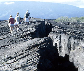
California Natives explore Isabela Island in the Galapagos.
California Natives hike over the volcanic terrain on the Galapago's Isabela Island (formerly called Albermarle Island).

The soldier looked again at the terrible landscape—thorny, dry vegetation, fields of sharp broken lava, and the volcanoes, following each other as far as his dry eyes could see.

Isabela Island, named after Queen Isabela of Spain, called Albermarle Island by the British, is the largest of the many islands and islets which make up the Galapagos. Larger, at almost 1,800 square miles, than all of the other islands put together. Six volcanoes form the backbone of the island, all but one of which are active, and the island, particularly the northern part, is wild and rugged.

In 1893, Don Antonio Gil settled on the island on a plantation he called Villamil. There he dabbled in agriculture and mining, rendered turtle oil, and exploited feral cattle for their hides. He also exploited the abundant tortoises, using their shells to decorate the path up to the plantation.

Thirty miles inland on the slopes of a mountain, he established a second plantation, Santo Tomas, primarily for mining sulfur from the fumaroles in the area.

Other plantations sprung up on the island as time went on because of it´s abundant resources. It was the custom in those days for plantations such as these to employ workers who were fugitives of the law. This made discipline on the plantations very harsh. Punishments could include death or exile, and some plantation owners traded workers for cattle.

As the plantations grew in size and number of workers, the owners petitioned the government of Ecuador for police and military protection, although there had been no trouble thus far on the island. In 1902 two small garrisons were dispatched to the island, consisting of a total of 12 soldiers. Nothing much happened, and the soldiers became terribly bored. So bored, in fact, that they decided to secretly leave the island.

In 1904, eleven of the soldiers quietly set out towards the interior of the island carrying neither water or supplies, certain they would be able to find a way back to the mainland. The owners of the plantations, realizing they were gone, searched for days but never found them.

After awhile, they gave up hope and had all but forgotten about the missing soldiers, when one of them, near death, reappeared at the plantation entrance. Once nursed back to health, he explained that the soldiers left thinking that such a big island should be filled with villages, and that they would be able to find sea transport back to Guyaquil. Overtaken by hunger and thirst, they began to hallucinate, and eventually separated. None, except the one survivor, was ever seen or heard from again.

There are so many strange stories, landscapes, and creatures on these islands which inspired Charles Darwin to discover the principles of evolution. Please join us our Galapagos Islands tours.

Blood, Gore, and a Mummy Mix-Up

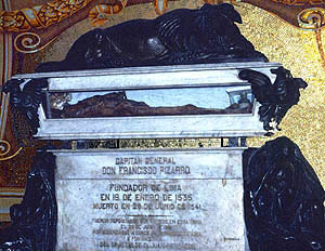
The mummy of Pizarro was an imposter.
At the cathedral in Lima, Peru, this mummy was mistakenly displayed for almost a century as the remains of Francisco Pizarro.

I first visited the Cathedral in Lima, Peru, in 1979, and saw the mummy of Francisco Pizarro. The mummy had been placed there back in 1891, when Peruvian officials, wanting to prominently display the “Founder of Lima,” had the body moved from the chapel in which it had lain for the previous 350 years.

But was this really Pizarro? Just prior to my visit, workers cleaning a crypt beneath the altar found two wooden boxes, one containing the bones of five people—one missing a head! The other box held a lead casket on which was inscribed in Spanish, “Here is the skull of the Marquis Don Francisco Pizarro, who discovered and won Peru and placed it under the crown of Castile.”

Francisco Pizarro died a violent death. On June 16,1541, while he was having dinner in his governor’s palace, a group of men, led by the son of his ex-partner, Diego de Almagro, broke in and stabbed him to death. As he lay dying from multiple sword wounds, he drew a cross on the ground in his own blood, kissing it, and crying “Jesus.” In 1892, his mummy was exhumed and displayed for almost a century in the Lima, Peru Cathedral, but was discovered to be an imposter when the underground crypt was discovered.

Pizarro had lived a cruel but exciting life. Born in poverty and illiterate all of his life, he sailed with several expeditions to the Americas, including Balboa’s journey to the Pacific. After settling in Panama, he formed a partnership with Almagro, a soldier, and Hernando de Luque, a priest, to explore the territory south of Panama, they discovered the Inca Empire. Pizarro then sailed to Spain to enlist the support of Emperor Charles V, from whom he received the charter to conquer and rule Peru. The

After the bloody conquest of the Incas, where 2000 Indians were slaughtered and Emperor Atahuallpa strangled, Pizarro alienated his partner, Almagro. This eventually led to armed conflict between the former partners, and Pizarro’s brother, Hernando, having Almagro garroted.

The skull in the lead box matched the headless skeleton and, when reunited, turned out to be a man approximately the right age and height for Pizarro at the time of his death. Additionally, the skeleton showed that the man had been murdered by multiple sword thrusts, unlike the mummy which, upon reexamination, showed no wounds, leading Peruvian and American scientists to conclude that the skeleton was indeed that of Pizarro. It is now believed that the mummy who had sat in for Pizarro for so many years, was a church official. He is now retired, and the “real” Pizarro’s bones have taken his place on display.

Costa Rica’s Bounty of Butterflies

Butterfly

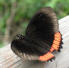
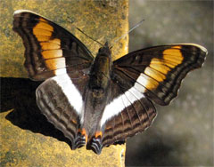
Throughout Costa Rica’s plentiful rainforests, beaches and mountains, visitors are enchanted by the number and variety of butterflies. Costa Rica boasts over 1000 butterfly species, more than the entire continent of Africa.

Flitting from flower to flower the butterflies are enchanting to watch, the brilliant colors of their wings lending joy to the day. These delicate wings are covered with tiny scales which reflect light passing through them to form bright colors and patterns. They serve to identify the butterfly to members of its own species as it seeks to carry out its sole mission in life, mating. The colors of some species, such as the Monarch, which are toxic when eaten, warn predators that these butterflies are not dinner.

Butterfly

The male butterfly spends his short time on earth cruising around looking for a female. With his antennae he can smell her perfume (pheromones) from over a mile away. At the back of his abdomen—remember, butterflies are insects so their bodies have three sections, a head, a thorax, and an abdomen—is a set of “claspers” to grab on to his lady love. When couples mate they face in opposite directions with their abdomens locked together. The female, if startled during the conjugal act, will fly up into the air carrying aloft her attached Don Juan. During her short lifetime she will lay about 100 eggs. Some species lay their eggs in clusters while others lay each egg on a different plant.

Butterfly

Upon hatching, the tiny caterpillars go into the world to eat. As adult butterflies are primarily sex machines, caterpillars are primarily eating machines, munching the night away, and remaining motionless during daylight hours to camouflage themselves from predators. The growing caterpillar sheds its skin four times, then searches for the perfect spot on the underside of a leaf to attach itself and prepare for the miraculous change from a crawling eating machine to a glorious flying butterfly.

The butterfly’s life is short, varying from species to species, but averaging about three months—two weeks as an adult butterfly.

Join us on a California Native tour to beautiful Costa Rica and witness this bounty of butterflies for yourself.

Traveling Easy With The California Native

Traveling EasyIts summer vacation time! As many of us travel this summer, we see longer lines, airline cut backs and fees, not to mention unpredictable weather. Here are a few simple tips to make your trip a wonderful adventure to remember.

Attitude is key! If you start with a good attitude, others you encounter will mirror that, and you can handle anything that happens.

Be flexible. Sometimes things happen, good or bad, changing your plans in an instant. If you are willing to just smile and “go with the flow,” you will certainly have an adventure, and it may even be better than the original plan.
Pack LightPack light. This can’t be emphasized enough. If you plan carefully, you’ll have everything you need and you can carry it on the plane, avoiding luggage fees. Pack layers instead of bulky items for cold weather. Pick a color scheme and pack mix- and-match items you can wear in many combinations. Have a master packing list on your computer. Before each trip, print it out, modifying it for the length of the trip and the weather.

Pack chargers for your iPod, cell phone, camera battery, computers, etc. Also pack an extension cord. This way, if the outlets in a hotel room are limited, you can plug three things on one cord, and if you need a voltage converter or adapter, you need carry only one. Pack loose batteries in a plastic bag in your carry-on. Since January 1, 2008, lithium batteries are permitted in checked luggage only if installed in the electronic device.

Pack everything in a carry-on suitcase and a backpack, in neat layers. Stow your carry-on in the overhead bin and your backpack under the seat (ladies, put your handbag in the backpack!). Make sure any liquids or gels are 3 oz. or under, and stored in one quart-sized zip-lock bag that is easy for airport security to inspect. Also, take some twist ties. These are great for securing zippers on luggage when you are on the move and can be taken off easily at security.

If you must check luggage, make sure you have your toiletries, medications, electronics and chargers, and a change of clothes in your carry-on. Lost luggage can put a real damper on a trip. Pack an extra bag that packs flat, for those once-in-a-lifetime purchases and souvenirs. Check this bag on the way home. Many airport luggage shops sell them. Check your airline’s website for any specific luggage restrictions.

Time Your ArrivalTime your airport arrival to give yourself enough time to get through security, but don’t arrive so early that you spend hours sitting around. Check to see which carriers fly from the same terminal. A lot of short-haul airlines usually mean a longer security line. Check your airline’s website for flight status updates which send text or voice messages to your cell phone advising you of your gate number, and changes, delays, etc. Since most U.S. domestic flights no longer provide meals, we like to get to the airport for a morning flight in time to get through security, then sit down and have a nice breakfast.

Speaking of food, if you are flying domestically in coach, bring your favorite snacks. Although airlines sell a variety of items, you’ll save money and have healthier snacks you enjoy. For flights during mealtimes, buy a sandwich and drink after going through security. If you buy them in advance, be careful about liquids—salad dressing, drinks, sauces, etc. may be confiscated.

Our packing essentials for any trip: bathing suit, hand sanitizer pads, or gel (in your quart-sized plastic bag), bandana (has many uses), extension cord, head lamp (great for reading), plastic bags, twist ties, small tripod for camera, small rolls of toilet paper, and most important, a good attitude and a smile.

Summer is also a good time to book your trips for the Fall. Check out all of our exciting vacation destinations.
El Fuerte Was the Capital of Arizona

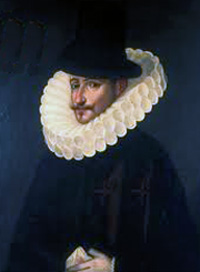
Juan de Mendoza Luna, Viceroy of Mexico and Peru in 1610.
In 1610, the Viceroy of Mexico and Peru ordered a fort to be built on a hill overlooking the town now known as El Fuerte, the first stop on California Native tours of Copper Canyon.

In 1610, Juan de Mendoza y Luna, the Viceroy of Mexico and Peru, ordered that a riverside fort be erected on a hill overlooking the town of San Juan Bautista de Carapoa, to defend it against attacks by fierce Mayo, Zuaque and Tehueco Indians, and to guard the rich haul of silver from its many mines. Founded fifty years earlier by the Spanish conquistador Don Francisco de Ibarra, the town was renamed El Fuerte, “The Fort.”

In successive years, El Fuerte became a major trading post for gold and silver from the mines of Urique, Batopilas, and other Sierra Madre settlements and a station on Spain’s fabled Camino Real trade route. In 1824, after almost three centuries as the most important commercial and agricultural center in northern Mexico, El Fuerte became the capital of the territory which now makes up the Mexican states of Sinaloa and Sonora, and part of Arizona. After a few years, and a few wars, its administrative functions were taken over by Culiacán, Hermosillo and Phoenix.

El Fuerte today, with a population of around 30,000, is a quiet, picturesque colonial town, but the old fort still looks down on the quaint cobblestone streets as they wind past its historic church, mansions and shops, many dating back to colonial times. El Fuerte is also the starting point for most of The California Native’s journeys through the spectacular Copper Canyon.

Touring the Tea Horse Road

California Natives in Dali, China.
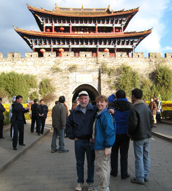
California Native's Lee and Ellen Klein in the ancient city of Dali in China's Yunnan Province. Dali was an important stop along the Tea Horse Road.

“My grandfather dipped his silver bracelet into the water, to make sure it was not poisoned,” related Chen Dong Mei, her eyes sparkling as she told us stories of her grandfather who drove horses along the historical Tea Horse Road. Mei was our guide in Lijiang, an ancient city in China’s western frontier province of Yunnan. It is in this area that the Tea Horse Road began, thirteen centuries ago.

Driving the horses and mules from Yunnan, China, through the high mountain passes of the centuries-old trail to Tibet was a dangerous occupation. Bandits were a constant threat and it is said that they would poison the streams where the drivers obtained water for their campsites. The silver in the bracelets, which the ethnic Naxi people still wear, would change color when exposed to the poison.

Tea was introduced into Tibet during the Tang dynasty, and a trade developed where the Chinese bartered tea for Tibetan war horses. The Chinese stopped buying horses from Tibet in 1735, but the trade in tea continued to grow.

The road starts near the tropical city of Jing Hong, where the famous Pu’er tea is grown. It then passes through Dali, Lijiang, Zhongdian (in 2001 renamed Shangri-La, in the hope that the name will attract more tourists), and onward to Lhasa in Tibet.

A second route begins in Sichuan province, the site of Yacha tea production, and leads up through some of the most treacherous passes in the world to Lhasa. From Tibet, branch trade routes led south into Myanmar (Burma), Nepal and India.

Even before the Tang dynasty, in the 7th century, the trail was a major route for migration and cultural communication, and ancient tombs along the way have been determined to be almost 5000 years old.

The Tea and Horse Road again became a critical transportation link during World War II, when Japan blocked highways from China and Burma to India. More than 25,000 horses and mules were used to haul everything from sewing machines and canned goods to whiskey and cigarettes over the ancient trails.

Today, the Tea Horse Road is a special route for many indigenous people in the region, which includes the greatest number of ethnic groups in China. Naxi, Dai, Bai, and Thai all have mountains in the region which are sacred to their various religions.

California Native’s tours of Yunan Province follow much of this ancient route.

Copper Canyon 2012

The road to Batopilas
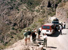
In Mexico's Copper Canyon, California Native guests stop to take photos on the road down to the remote village of Batopilas.

Memorial Day is coming up and it’s time to start planning your fall and winter adventures. We have just published our 2012 schedule of tours to Mexico’s Copper Canyon. We haven’t announced our 2012 prices but if you sign up now, we will honor our 2011 prices for your 2012 trip.

And, yes, our guests in Mexico are safe. We are often asked about the safety of traveling in Mexico in light of the media sensationalism about the government’s campaign against the drug traffickers. Mexico is a very large country and the violence has been mainly in cities along the U.S. border. None of it has any effect on the destinations we travel to and no tourists have been involved in any incidents. Putting it into perspective, it would be the same as avoiding travel to Yosemite because there was an incident in New York City. This coming October more than 40 countries will be sending their athletes to participate in the Pan-American games in Guadalajara, Mexico.

Her Uncle Rode With Pancho Villa

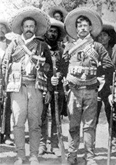
Francisco "Pancho" Villa and Ricardo Gonzalez
Ricardo Gonzalez, great uncle of Bessie "Crickett" Quijada.

A few weeks ago we received a very interesting comment from Bessie "Crickett" Quijada regarding our article, A Visit With Mrs. Pancho Villa. I contacted her and she agreed to share some of her photos with us.

In her comment Mrs. Quijada told us “My grand mother’s brother, Ricardo Gonzales, rode with The General Pancho Villa. In the Military Classics Illustrated (News Letter) there is a photo of My great uncle Ricardo on horseback along with Pancho Villa and about 5 or 6 other riders. My uncle is to Pancho Villas left. I have a photo of my uncle with Mrs Pancho Villa (Dona Luz) taken at La Quinta Manor where she lived until her death. The Villa’s manor is a museum in Chihuahua, MX. In the Military Classics Illustrated along with the photo of my uncle with Pancho Villa there is an article titled, The Villistas: Soldiers in Sombreros and Suit Coats By Don Fuchik.”

The author she refers to, Don Fuchik, was a very close friend of mine from the time we were 13-years old until his death a few years ago. He was also a consultant for The California Native and led many of our trips through Mexico’s Copper Canyon.

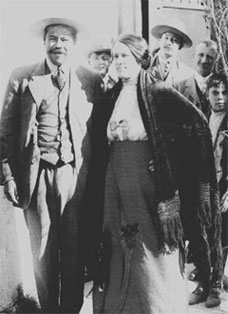
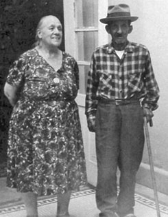
Pancho Villa and Luz Corral de Villa Dona Luz Corral de Villa with Ricardo Gonzalez
Pancho Villa and his wife, Luz Corral de Villa, in 1914. Dona Luz Corral de Villa with Ricardo Gonzalez in 1967.

Crickett was born in Denver, Colorado and grew up in Stockton, California. She now lives in Fresno. She describes herself as being 67 going on 12, and never wants to grow up. She has eight children, two which she adopted, and two male pet hooded rats whom she adores (she claims that rats make great pets). Her nickname is Crickett and that is what she prefers to be called.

Does Anyone Have a Virgin to Sacrifice?

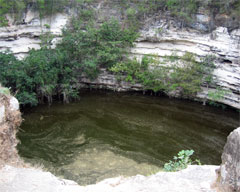
The Sacred Well of Chichen-Itza
Maidens were sacrificed to the Rain God Chac in Chichen-Itza's Sacred Well.

My first introduction to the Mayans was in a grammar school textbook where our fourth grade class read a story titled “The Sacred Well of Chichen Itza.” I was fascinated with the tale of the young maidens being thrown into the well to be sacrificed to the Rain God Chac. This was back in the 1940’s and more than 20 years passed before I first traveled to Chichen Itza and stood before that very same well—too late to rescue a maiden but a wonderful time to conjure up visions of a past when exotic civilizations populated the Americas.

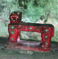
The jaguar throne of Kukulkan
In an inner chamber of Chichen-Itza's largest pyramid sits the jade-eyed jaguar throne of Kukulkan.

The Yucatan Peninsula is the homeland of the Mayan people, whose mighty empire lasted over a thousand years. Throughout the peninsula are the amazing archaeological ruins of their great cities—Chichén Itzá, Uxmal, Edzna and many more—a fantastic place to take a time-traveling vacation. In addition, there are lovely colonial cities, forts designed to protect against Caribbean pirates and beautiful beaches.

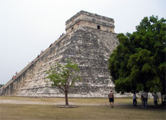
Pyramid El Castillo in Chichen-Itza
The El Castillo pyramid dominates the ruins of the Mayan city of Chichen-Itza

After leaving the sacred well, I climbed a passageway cut into the great pyramid called “El Castillo” into an older pyramid covered by “El Castillo.” Here in an inside chamber I gazed upon Kukilkan’s red jaguar throne, its eyes and spots glittering with jade and its fangs glowing with pyrite. After exiting with the tourists I wandered alone in the ruins where I found a little entrance in the side of a pyramid and entered a narrow passage. Gradually the outside light from the entrance grew dimmer and dimmer and then my little pocket flashlight stopped working. I found myself alone in the pitch-black. Very creepy. I felt my way back up the tunnel, imagining the possibility of getting lost in an underground labyrinth and was very happy when I emerged into the sunlight—Indiana Jones would have been proud.